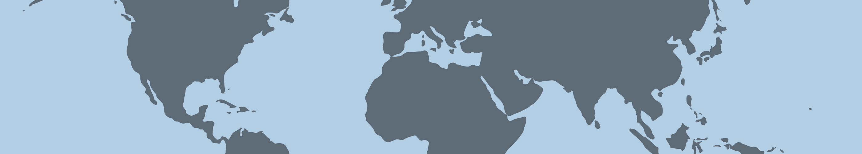

The RMI's Global Risk Map, is a risk assessment tool that allows users to identify and compare governance, human rights, and conflict risk indices across geographic regions globally. Utilizing the internationally recognized indicies and resources identified in the European Commission's non-binding guidelines for the identification of conflict affected and high risk areas and other supply chain risks, the tool classifies geographic areas as low-, medium-, high-, and extreme-risk in an interactive and up-to-date world map. The tool also flags sanctions risks based on the United Nations, U.S. and E.U. sanctions lists. Users can view all country risk classifications at a global level, zoom-in to detailed indicators at a country or area level, and download the complete underlying dataset for further sorting and analysis outside of the tool.
The Global Risk Map is only available for the RMI partner members, upstream members, as well as the RMI auditees directly participating in the Responsible Minerals Assurance Process (RMAP) or Downstream Assessment Program (DAP).
RMI Global Risk Map at the subnational level is a pilot project with limited data and should not be relied on solely without any additional back up evidence for the purposes of CAHRA identification. The sub-national data is incomplete at this time; the data is only partially available and only fully verified for 11 countries (and within those countries that data is also not fully available because there is scarcity of such sources). If there is sub-national risk information for one area in the country but not others, that means the other information WAS NOT AVAILABLE and not that the rest of the areas are low risk.
To access the Global Risk Map - Risk Assessment Tool click below.
If you are a current RMI member or RMAP participant and you are looking for your access information, please contact us.